The Drive from Durango to Hartsel, Colorado
 |
| It looks depressing, but my favorite thing in the San Juans is the afternoon "monsoons" |
We left Erin and Chads (thanks guys!) in the morning and did a short segment of the
Alpine Loop Scenic Byway on our way up to Hartsel. The full Loop is a 65-mile drive that snakes through the San Juan Mountains, passing old mining towns and through some spectacular mountains. Don't take it if you're in a hurry, though -- the speed limit is often 35 miles and hour as you switchback up and down to the passes, with several hundred foot drops (and often no guardrail) just a few feet passed the wheels. We only did the "Million Dollar Highway," Rt. # 550 section from Durango up to Montrose, but I'd definitely like to do the whole loop next time (preferably on a motorcycle).
 |
| The Beaumont Hotel in Ouray, Colorado |
 |
| There's much more here than the Beaumont, but I loved the contrast |
Our goal was the land that I own in
Hartsel, Colorado (I saw "own," but it's mostly a parcel of remote high plains property that I've paid property taxes on for over 20 years):
 |
| Hartsel, Colorado |
My mom, a city girl from Chicago, had always had a dream of owning land "out West" and, enchanted later in her life by a barrage of commercials for the
Hartsel Ranch on TV, bought this land on a whim, sight unseen. When she passed away, my step-dad Ed gave the land to me because he knew that I was I had my own fantasies about life out West. I've been to the property exactly three times in my life: in my
early teens on a family road-trip with mom to Mexico (I seem to remember that this was mom's first time as well); when I was
thirty and we were nearby at a dude ranch family reunion (with Chad); and
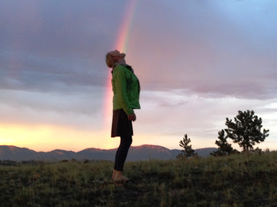
now, passing through with Erin. Other than Chad and Erin, I'm the only Page who's seen this property in over forty years. We almost weren't going to camp here, as there was intermittent rain and some very threatening thunderheads in the area, but we decided to go for it and, as the sun dropped behind the hills, we were treated to the most magnificent sunset that I've seen in years. Here are two pictures, which don't quite capture the awesomeness, but maybe hint at it just a little bit:
And capped off with a
rainbow:
. . . that Erin ate up:
. . . prompting me to have a taste:
 |
| Notice the double rainbow |
I made this
map when I came out to the property on my second visit (with Chad, about twenty-odd years ago). After driving around half a day with Chad -- I only had a vague impression of what the property looked like from when I was a kid, but I swore I'd know it when I saw it! -- we went back into town and saw a stack of old surveys scattered on top of a table in a shuttered up realty office. We talked a guy in a garage in the adjoining building into letting us in and, using the legal description I had, we managed to figure out where the property was located. (I forgot to bring the map on this trip -- Doh! -- but I called Jenny, who found the map in my drawer, took a picture with her iPhone and emailed it to me).
 |
| My map of the Hartsel property (now you can find it with Google maps, of course) |
Here's a picture of the
cross that's on top of the hill on the back edge of the property. I'm not a big fan of the prominent display of crosses (you can see it from quite a distance), but I remember mom telling us kids on our first visit the story about someone -- an Indian? a pioneer? Elvis? -- buried underneath these rocks. Is this the same cross from forty years ago? I'm sure this was just a fanciful tale concocted by a woman on a long roadtrip, devised to amuse, delight or perplex a van full of kids . . . but still it haunts me.
 |
| Is there someone buried beneath this mound of rocks. Mom took this mystery to her grave. |
 |
| The view from atop Mary Jane Mountain |


Great photos, cool hotel against the rocks, nice double rainbow all the way, and yes I bet there's at least one body lying beneath the cross.
ReplyDeleteMust see: http://www.youtube.com/watch?v=OQSNhk5ICTI
:-)